BED & BREAKFAST
A 2 PASSI DAGLI DEI
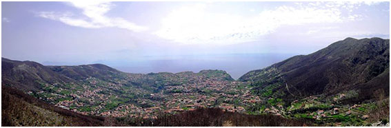
Agerola lies in the centre of a luxuriant green valley at an altitude of 600 meters above sea level. The sensation is of being completely surrounded by a lush and exuberant nature with breath-taking views (especially if one looks towards the sea!).
The name Agerola is almost certainly derived from the Latin “Ager”, meaning vast field. This, together with the discovery of Roman artifacts, confirms the antique origins of the town.
Agerola is not more than half an hour from towns like Amalfi, Positano, Ravello, Pompei and Sorrento and so it is an ideal location from which to take day trips to the towns or the coastal beaches.
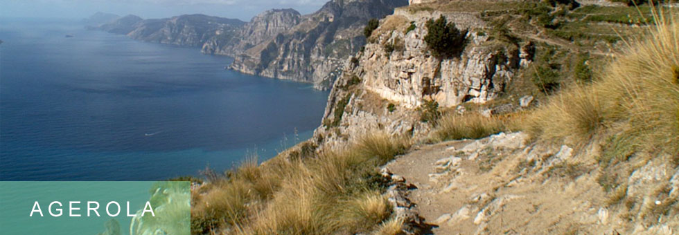
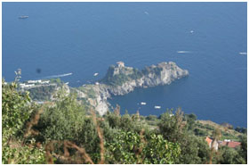
In addition, Agerola is the starting point for the “Sentiero degli Dei” (The Gods’ Footpath) – the justly most famous walk anywhere on the Amalfi Coast. In the past Agerola was part of the Amalfi Republic and was the principal source of wood used for construction of the ships for the Republic’s fleet- It furnished Italy (and Europe) with silk. Today thanks to a growth which is respectful of the environment and local traditions – Agerola offers ever more to its visitors .
HIKING AND TREKKING
GOD’S PATH (length: 7 Km)
One of the most famous and suggestive walks of the world, the God’s path gives an overview of the paradise to its visitors.
Departing from Bomerano main square, you willmove along the daring mule track that for centuries represented the sole connection between Agerola and Positano. Along the way you will admire terraced wine and lemon-yards alternating with spots of wild vegetation, ancient rock houses and other examples of vernacular architecture. All that integrated in a landscape made of high precipitous cliffs and deep gorges facing the cobalt blue water of Salerno Gulf. Opportunity to swim and return to Agerola by public bus.
TRE CALLI’S PATH (lenght: 6 Km)
Starting from Bomerano’s square going up towards Pendola and Paipo past the Casino house (ancient house) as far as Capo Muro’s ridge turning south along the Calavrice crest reach Mt. TreCalli with 360 degree view overlooking Agerola and Amalfi Coast.
PINO’S GORGE PATH ( length: 5 Km)
Departing from Bomerano’s square a mule track brings to Santa Barbara. Crossing the valley beneath the grotto one reaches the main road. Walking along it one encounters the path that leads into the gorge of Schiato’s torrent. Crossing the stream next to the ancient mill and climbing up one will reach San Lazzaro.
IRON FOUNDRY’S VALLEY ( length: 4 Km to protect area / 6 km to Amalfi)
Departing from San Lazzaro main square, we will first climb to 850 m a.s.l. on Mt. Murillo (wide panorama on the Amalfi Coast) and then cross the Vocito Valley, drink at the Acquolella spring and descend the woody flank of the Valle delleFerriere canyon, which is a protected area. After admired the Canneto waterfall and the very rare fern Woodwardiaradicans, we will move downstream to Amalfi seeing ruins of ancient mills, terraced lemon yards and examples of the local vernacular architecture along the way.
SPRING’S PATH (lenght: 5 Km)
Next to the “Leggia” waters’ spring in Campora, a path skirts in a green valley along the Penise river between chestnut woods. On the way can be admires some ancient craggy refuges and the ruins of an old borbonianpowder magazine. Later many springs: Fiubana, San Giuliano, AcquaFredda and finally at 1.000 meters there is the Vrecciara spring with an astonishing view of mount Vesuvius and the Gulf of Naples.
PRAIA’S PATH (length: 4 km)
Departing from Bomerano’s square this path follows the medieval mule track which connected Agerola to Praiano. Walking the first section you are confronted with a high, pink cliff which open several cavities, including the Grotto of St. Barbara. The long stretch that wanders along the side of the Vallone Praia, shows all of the changing aspects of the vegetation that characterize the low to mid slopes of the coast. In the meantime you can look up at the summit of Mt. TreCalli and down into the narrow gorge leading to the end of the valley.
GIANT’S TEETH PATH (length: 7 km)
Behind S. Peter’s church in Pianillo there is a mule track that goes up to Locoli and the Sughero’s hill, where intersecting the “High Lattari’s way” and going west rounding the pyramidal shape of Mt. S. Angelo one reaches the Blessed Water’s cave. A small climb will bring on top of the Lattari chain’s highest peack.
DAWN’S PATH (length: 4km)
Starting from San Lazzarocentre, going up the main road to Radicosa and then on the ancient mule track that leads to Muriello’s mountain. Circling south east the mountain and turning south it finally reaches the medieval Cospita convent.
Clicking here (official website of the town of Agerola) you will see a comprehensive list points to visit in Agerola.
AGEROLA: THE SECRET OF IDEA
They believe in the success of their idea because Agerola has become a sought-after tourist destination thanks to:
ITS STRATEGIC LOCATION – being nearby to the picturesque Amalfi coastal towns of Poitanto, Amalfi, Sorrent, Ravello and a day trip away from Pompei and Naples.
THE LANDSCAPES – the lush valley is surrounded by a mountain chain from which the mule-track called The Giants’ Teeth winds it way, the breathtaking views of the Amalfi Peninsula and the sea and the coastal mountains which dive directly into the sea.
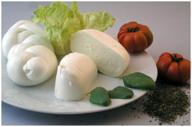
THE ENO-GASTRONOMIC PALETTE –here is the home of Buffalo Mozzerella and Monk’s Provalone cheeses, world class Agerola salame, Durham sheat bread, the tarrali (a kind of bagel/prezel), Pennett pears, Sorrento’s lemons and tomatoes. Local wines include: Falanghina, Piedirosso, Aglianico
THE GODS’ FOOTPATH –Agerola is the starting point for the most famous walking trail in Italy.
LOCAL TRADITIONS – Here antique crafts are still alive! The Casa della Corte Museum displays tools of local crafts and agriculture and shops and laboratories in Agerola and the Amalfi coastal towns make the works available for you to take home with you.